Map of Omaha Beach German fortifications (blue dropets) laid over the American operational map for June 6, 1944 (misaligned due to Google Maps limitations). Clicking the button “Google Earth” will show the 3d Model of the German fortifications and will correctly align the overlay map. Use upper left wheel to tilt the image. You might be prompted to download the Google Earth 3D Plugin.
Purdue and Indiana University team recreates D-Day battlefield, launches learning environment where information searches for user
I lead a group of Purdue and Indiana University researchers in commemorating the 65th anniversary of D-Day by releasing the first version of a 3-D, interactive model of the Omaha Beach battlefield. The project is the product of the united efforts of colleagues and students from Purdue’s Department of Communication, AVL lab IU/IUPUI, Envision Center and the Center for Advanced Wireless Applications at Purdue University.
A demonstration was given on June 2nd at the Advanced Visualization Lab Tuesday on the Indiana University-Purdue University Indianapolis campus. The event demonstrated the 3-D model of a key battlefield in the allied invasion to liberate France on June 6, 1944, and several methods of using the system for learning.

See the Omaha Beach Model in Google Earth Stand Alone Version
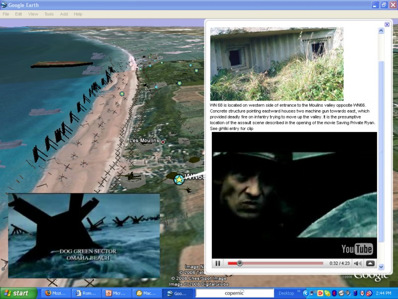
The model, which includes 3-D pillboxes, beach obstacles, field guns, or ships is, in effect, a Web interface, and is part of my bigger project Visible Past. VP works like this: when visualizing a 3D object you can call up more information, collaborate with other learners, or add new information just by pointing to an object or location of the virtual space. Virtual Omaha is one of the more than two dozen 3-D models, including several UNESCO World Heritage sites, that can be used for teaching and collaboration through the Visible Past project. The models, some of which were created collaboratively by a worldwide community of students, scholars and amateur historians, are enhanced with information collected by Purdue students. Among the projects under development are the Roman Forum, the Taj Mahal and the Statue of Liberty.
Students using Virtual Omaha can walk or fly through the model of the beach and the French countryside behind it, taking the perspective of the American or German troops. They can inspect troop positions from all angles and information about the digital artifacts encountered can be brought up automatically. The really novel aspect of the project is that if another group uses the model while you are visiting it, any information that they add to it will become available to you instantly. Besides the Web, the Visible Past models can be run in 3-D virtual environments like the three-walled, room-sized system at the Envision Center, in West Lafayette, or at the AVL lab, on the IUPUI campus, in Indianapolis. They also work in Google Earth or through free, open source software for 3-D Web-based modeling. In the near future, people visiting Omaha Beach in Normandy, France, will be able to use an iPhone application, also developed by us, to access the model and collaborate remotely with others. We will probably have professors delivering a tour to a group in Normandy, while students in Indiana will be able to see and hear through (an immersive virtual environment) what their colleagues see and do in France. The iPhone application also can be used as a “location-aware” guide for Omaha Beach or any historical site documented by the Visible Past project. When visiting the Roman Forum, for example, information about the nearest building could be sent automatically by Visible Past to the iPhone. In a word, this is ubiquitous computing, where information searches for you.
Directions to Virtual Omaha demonstrations:
Related Web sites:
Virtual Omaha article in the Purdue Exponent
Omaha Beach, 3-D VRML model (requires plug-in)

Thanks for the note…
Virtual show is a great way to promote tourism and encourage people to visit.
So, in saving private ryan, the C company fought on dog green sector, but the place where they fight isn’t on wn-71 right, because we can’t see in the movie the d-1 draw, so i think, the only strongpoint that i saw in google earth in dog green that have a concrete mg bunker like in the movie is on wn-70, can you help me on it? because i’m mapping each secotr of dog green with the correct german fortifications, and i want to know if the bunker that appear in the movie is a real model and if it was placed on normandy beache on 1944, thanks, and sorry the bad english i’m french…